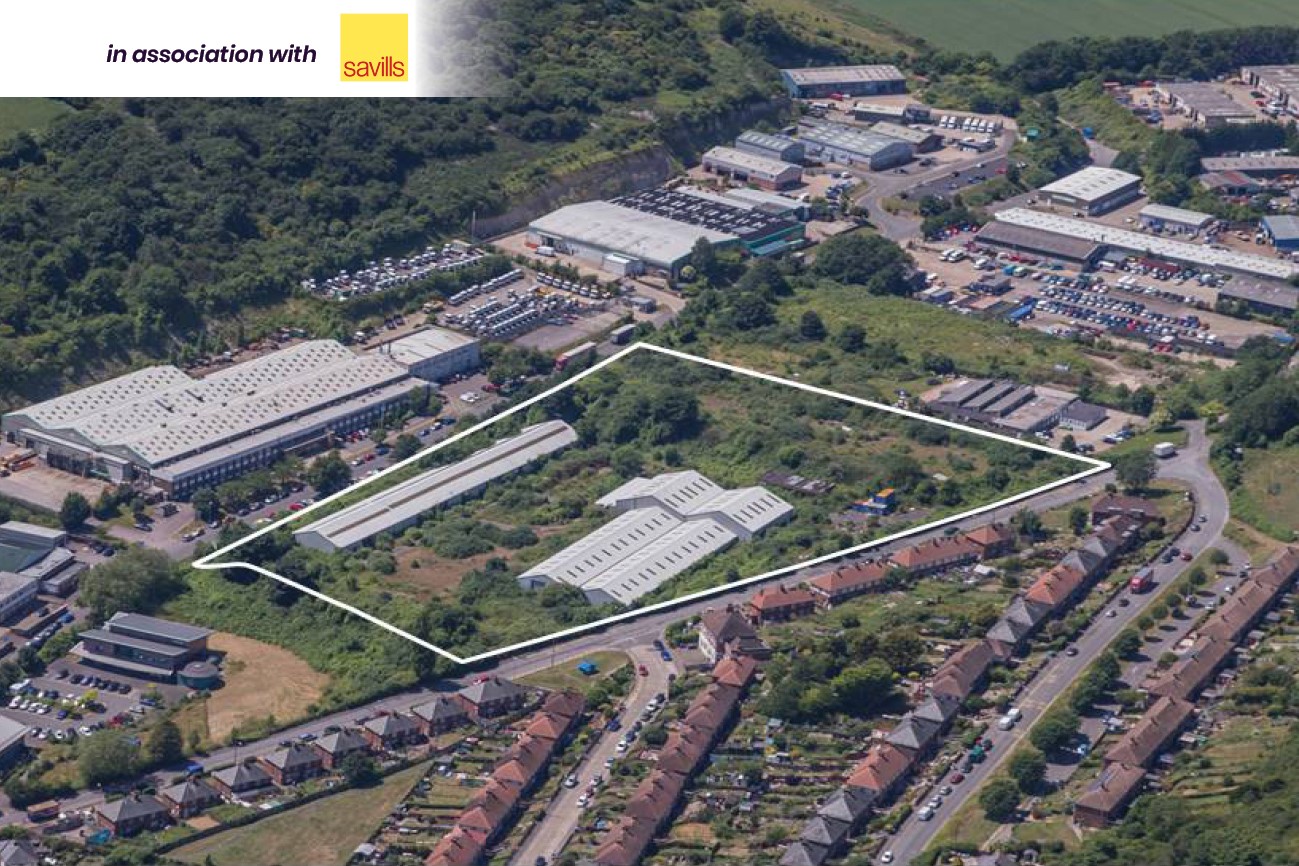
Land at Barwick Road, Dover, CT17 0TJ
-
Δημοπρασία
- Ακίνητο 03
- Ηνωμένο Βασίλειο
- Τεμάχιο/Γη
- Εμπορικό
Πωλήθηκε για £796,000
Προσθήκη
Περίληψη Ακινήτου
- Vacant former industrial premises with development potential
- Approximately 52,500 sq ft of buildings
- Outline planning permission for up to 220 dwellings (now lapsed)
- Site area of 6.32 acres (2.56 hectares)
Επικοινωνήστε μαζί μας

Επικοινωνήστε μαζί μας

Λήψεις Αρχείων
O BidX1 Λογαριασμός σας
Συνδεθείτε στον BidX1 λογαριασμό σας για να δείτε τα νομικά έγγραφα.
Δημηουργία Καινούριου Λογαριασμού
Κάνετε εγγραφή στην BidX1 για να δείτε τα νομικά έγγραφα.
Περιγραφή ακινήτου
The property comprises a vacant irregular shaped brownfield parcel of land extending to 2.56 hectares (6.32 acres). The majority of the site is spread over gently sloping topography. There are three existing buildings on site which total approximately
4,877.37 sq m (52,500 sq ft). The buildings have been damaged in places so are in poor to fair condition. Surrounding the buildings are large areas of hardstanding which are currently overgrown and include strands of Japanese Knotweed. We understand previous uses of the site include a workhouse, car distribution centre and brickworks. Surveys of the Property have revealed that it is registered as a licensed inactive landfill site with made up ground and traces of contamination. Remediation and foundation design will need to take this into account. The property is not located in a flood risk area.
Τοποθεσία
The Property is located in Dover, Kent, a historic town on the southeast coast.
Surrounding centres include Folkestone (8 miles), Canterbury (18 miles) and Ashford (23 miles). Eurostar and Eurotunnel connections are available at Folkestone whilst Dover port provides regular ferry services to the continent. M20 and M2 motorways provide connectivity to the wider road network.
The Property is situated within the Combe Valley area and is bounded by Barwick Road to the north, Poulton Close and commercial property to the south and the Triangle Community Centre to the west. There is vehicular and pedestrian access to and from Barwick Road, a residential area comprising semidetached houses. Poulton Road is characterised by light industrial and commercial properties. Dover town centre is located 1.8 miles southeast from the property. Dover Priory railway station is 1.8 miles from the property and provides services around the southeast including London St Pancras within a 65 minute journey. Shops and local amenities are all located within walking distance and bus services are also available. Attractive and protected countryside is also situated to the west of the property further along Barwick Road.
Άδεια Οικοδομής / Πολεοδομική Άδεια
The local planning authority is Dover District Council who we understand are keen to see the property developed. The property is identified as falling within Policy LA8 of the Dover District Council Land Allocations Plan 2015. The Property is not situated in a conservation area nor is it listed. The property did benefit from outline planning permission (now lapsed) for the erection of up to 220 residential dwellings including vehicular access and associated works (ref DOV/12/0011 granted December 2014). The first application for approval of reserved matters needed to be submitted no later than three years from the date of permission. A related s.106 agreement required the payment of various financial contributions and 30% affordable housing within the dwelling mix. The permission was obtained by a previous owner and covers a small parcel of land (situated to the south west corner of the Property) that is not within the ownership being sold. The permission has now lapsed. We understand that Dover District Council would be amenable to alternative development schemes. There is also potential for ongoing commercial uses and/or mixed use development.
Κατοχή
Freehold
ΦΠΑ
Βοηθητικοί σύνδεσμοι
*Όροι Χρήσης της Ιστοσελίδας
Buyers are strongly advised to read these terms and conditions, and check the Special Conditions and any applicable Addendum, prior to bidding on a Lot. Additional costs, charges and encumbrances may apply for Buyers once they have made a successful bid in relation to a property.
- The reserve price is the minimum price at which the property can be sold at auction.
- Where a guide price (or range of prices) is given, that guide is the minimum price at which, or range of prices within which, the seller may be prepared to sell on the date on which the guide price, or range of prices, is published. The sale price, whether prior to or at the auction, can be above or below the guide price depending upon market activity. BidX1 and the seller accept no responsibility for any losses, costs or damages incurred by a buyer as a result of relying on any guide price. The buyer must decide how much they should bid for any Lot. All guide prices are quoted subject to contract. Guide prices given by BidX1 or the seller cannot be accepted by the buyer as being a professional valuation for any purpose in accordance with the requirements or guidance notes of relevant professional bodies or other authorities.
- Both the guide price and the reserve price may be subject to change up to and including the day of the auction. Whilst every effort is made to ensure that these guides are not misleading, it is possible that the reserve price set for any Lot may exceed the previously quoted guide price (as the seller may fix the final reserve price just before bidding commences).
- The guide price for the Lot does not include the buyer’s fee of £1,295 (inclusive of VAT) for all properties up to £49,999, and £2,400 (inclusive of VAT) for all properties £50,000 and above charged by BidX1. In the case of a joint agent this buyer’s fee will be £2,700 (inclusive of VAT). In addition, the guide price does not include VAT on the sale price, or any additional costs, charges or encumbrances that might apply to some Lots and/or some buyers. The Special Conditions of Sale of the seller, and any applicable Addendum, will state if there are other costs, charges or encumbrances and whether the seller has elected to charge VAT on the sale price.
- To participate in the sale BidX1 must hold a minimum amount from all bidders. This participation amount and buyer’s fee is fully refundable in the event that you are not the successful purchaser. For example, a participation fee of £4,795 comprises £3,500 relating to your bidder security (partial deposit payment) and a buyer’s fee payable directly to BidX1. A higher participation amount may be payable depending on the reserve price of the Lot.
- Please note that Lots may be sold or withdrawn prior to auction.
- All Lots sold “Subject to Vendor Confirmation” will be subject to acceptance and confirmation by the Vendor. The highest bid will be presented to the Vendor, the Vendor will have to either accept, decline or make a counteroffer, within the confirmation period. Should the Vendor decide to make a counteroffer, then a private link will be sent to the Highest Bidder advising of the offer the Vendor is willing to accept. The Highest Bidder will be obliged to accept or reject the Vendor's counteroffer. The Vendor reserves the ultimate right, apart from the auctioneer, to accept and to decline to sell to the highest or any bidder, without giving any reasons.
- No information, statement, description, quantity or measurement contained in any sales particulars or given orally or contained in any webpage, brochure, catalogue, email, letter, report, docket or hand out issued by or on behalf of BidX1 or the seller in respect of the property shall constitute a representation or a condition or a warranty on behalf of BidX1 or the seller. Any information, statement, description, quantity or measurement so given or contained in any such sales particulars, webpage, brochure, catalogue, email, letter, report or hand out issued by or on behalf of BidX1 or the seller are for illustration purposes only and are not to be taken as matters of fact. Any mistake, omission, inaccuracy or mis-description given orally or contained in any sales particulars, webpage, brochure, catalogue, email, letter, report or hand out issued by or on behalf of BidX1 or the seller shall not give rise to any right of action, claim, entitlement or compensation against BidX1 or the seller. All bidders must satisfy themselves by carrying out their own independent due diligence, inspections or otherwise as to the correctness of any and all of the information, statements, descriptions, quantity or measurements contained in any such sales particulars, webpage, brochure, catalogue, email, letter, report or hand out issued by or on behalf of BidX1 or the seller.


