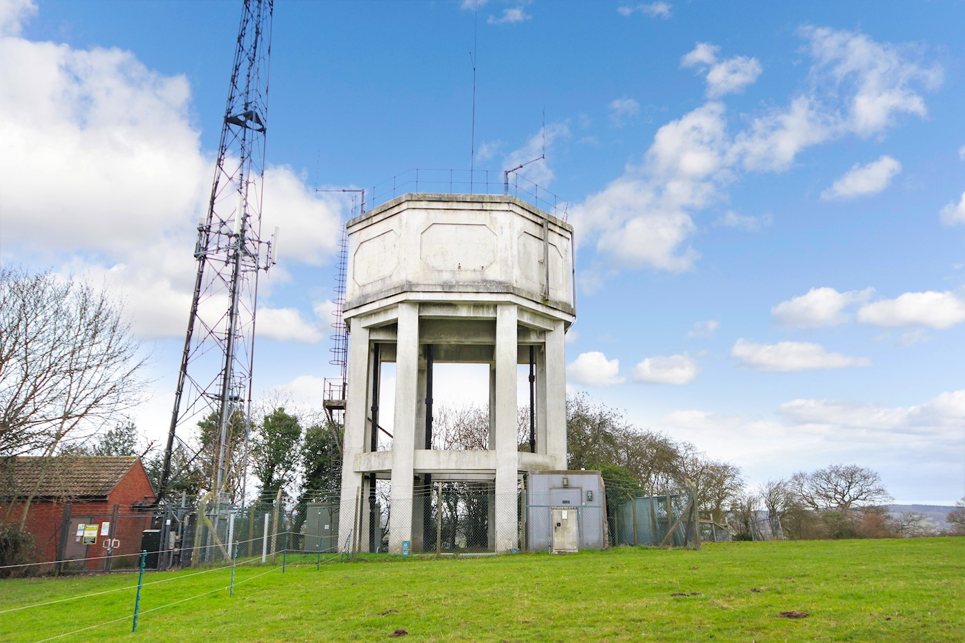
Tasley DSR, off Church Lane, Tasley, near Bridgnorth, WV16 4SA
-
Subasta
- Lote 14
- Reino Unido
- Tierra/Sitio
- Comercial
Vendido por £100,400
Resumen de la propiedad
- By order of Severn Trent
- Freehold disused water tower with vacant possession
- 0.07 acres (0.028 hectares)
- This Lot will not be sold prior to auction
Contactar con nosotros

Contactar con nosotros

Descargas
Tu cuenta de BidX1
Inicia sesión en tu cuenta de BidX1 para ver los documentos legales.
Crear una cuenta
Crea una cuenta de BidX1 para ver los documentos legales.
Descripción de la propiedad
The property comprises a prominent free-standing octagonal water tower. The elevated tank is supported on eight legs with a steel ladder running up one side to the dome of the tower where there is a railed perimeter. The property occupies an elevated position and is surrounded by a secure fence and includes a service structure.
We understand that utility services including water, electricity and telecoms are located at the site boundary. Interested parties should refer to the legal pack and make their own enquiries to satisfy themselves on the availability of any service.
Ubicación
Bridgnorth is an attractive and historic town located on the banks of the River Severn which splits it into a High Town and Low Town linked by a funicular railway, the Castle Hill Railway, which is the steepest and only inland railway of its type in England. Bridgnorth developed as a market town at the centre of a system of local radial roads including the A485 to Shrewsbury, the A442 to Telford and A454 to Wolverhampton. The town is 9 miles from the M54 motorway. Tasley is a village located just to the north west side of the town in the midst of open countryside. Church Lane is a road that connects a residential area with the countryside and is a popular route for walkers. The Church of St Peter and St Paul can be found here with the property lying alongside which can be accessed by a pedestrian right of way from the car park through a neighbouring field to the east of the site.
The approximate position of the property can be located as follows:
Grid Reference: SO69 6940
www.gridreferencefinder.com
Planificación
Dalcour Maclaren have provided an independent planning appraisal for the site that can be downloaded from the legal pack. Part of their Executive Summary states:
"The existing structures afford the site the status of previously developed land (PDL). The site is in a picturesque rural setting with rural views to the open countryside beyond. There are scattered rural dwellings nearby, taking advantage of the tranquil setting. Subject to structural integrity, the tower itself could offer the opportunity for re-use and conversion and this re-use of the building would be supported by policy. The potential land use options considered within this appraisal accord with several of the Local Plan Policy objectives covering environmental, social and economic targets. Four potential uses have been identified:
- Creation of a residential dwelling either through conversion of the existing building/structures or demolition of the existing and construction of new
- Part or full conversion of the existing structures for a non-residential use
- Creation of industrial units or general storage following demolition of the existing
- Creation of battery storage if there is renewable energy in the locality
The site is considered to be suitable for small scale redevelopment within the footprint of the site."
The above is for information purposes and should be read in conjunction with the full report contained within the legal pack. Further enquiries should be directed to Shropshire Council www.shropshire.gov.uk
Estado de Ocupación
Freehold
Estado ocupacional
Note: Interested parties should read the legal pack for further information relating to easements and overages, for example, that may be applicable to the site.
Impuestos
*Términos y condiciones
Buyers are strongly advised to read these terms and conditions, and check the Special Conditions and any applicable Addendum, prior to bidding on a Lot. Additional costs, charges and encumbrances may apply for Buyers once they have made a successful bid in relation to a property.
- The reserve price is the minimum price at which the property can be sold at auction.
- Where a guide price (or range of prices) is given, that guide is the minimum price at which, or range of prices within which, the seller may be prepared to sell on the date on which the guide price, or range of prices, is published. The sale price, whether prior to or at the auction, can be above or below the guide price depending upon market activity. BidX1 and the seller accept no responsibility for any losses, costs or damages incurred by a buyer as a result of relying on any guide price. The buyer must decide how much they should bid for any Lot. All guide prices are quoted subject to contract. Guide prices given by BidX1 or the seller cannot be accepted by the buyer as being a professional valuation for any purpose in accordance with the requirements or guidance notes of relevant professional bodies or other authorities.
- Both the guide price and the reserve price may be subject to change up to and including the day of the auction. Whilst every effort is made to ensure that these guides are not misleading, it is possible that the reserve price set for any Lot may exceed the previously quoted guide price (as the seller may fix the final reserve price just before bidding commences).
- The guide price for the Lot does not include the buyer’s fee of £1,295 (inclusive of VAT) for all properties up to £49,999, and £2,400 (inclusive of VAT) for all properties £50,000 and above charged by BidX1. In the case of a joint agent this buyer’s fee will be £2,700 (inclusive of VAT). In addition, the guide price does not include VAT on the sale price, or any additional costs, charges or encumbrances that might apply to some Lots and/or some buyers. The Special Conditions of Sale of the seller, and any applicable Addendum, will state if there are other costs, charges or encumbrances and whether the seller has elected to charge VAT on the sale price.
- To participate in the sale BidX1 must hold a minimum amount from all bidders. This participation amount and buyer’s fee is fully refundable in the event that you are not the successful purchaser. For example, a participation fee of £4,795 comprises £3,500 relating to your bidder security (partial deposit payment) and a buyer’s fee payable directly to BidX1. A higher participation amount may be payable depending on the reserve price of the Lot.
- Please note that Lots may be sold or withdrawn prior to auction.
- All Lots sold “Subject to Vendor Confirmation” will be subject to acceptance and confirmation by the Vendor. The highest bid will be presented to the Vendor, the Vendor will have to either accept, decline or make a counteroffer, within the confirmation period. Should the Vendor decide to make a counteroffer, then a private link will be sent to the Highest Bidder advising of the offer the Vendor is willing to accept. The Highest Bidder will be obliged to accept or reject the Vendor's counteroffer. The Vendor reserves the ultimate right, apart from the auctioneer, to accept and to decline to sell to the highest or any bidder, without giving any reasons.
- No information, statement, description, quantity or measurement contained in any sales particulars or given orally or contained in any webpage, brochure, catalogue, email, letter, report, docket or hand out issued by or on behalf of BidX1 or the seller in respect of the property shall constitute a representation or a condition or a warranty on behalf of BidX1 or the seller. Any information, statement, description, quantity or measurement so given or contained in any such sales particulars, webpage, brochure, catalogue, email, letter, report or hand out issued by or on behalf of BidX1 or the seller are for illustration purposes only and are not to be taken as matters of fact. Any mistake, omission, inaccuracy or mis-description given orally or contained in any sales particulars, webpage, brochure, catalogue, email, letter, report or hand out issued by or on behalf of BidX1 or the seller shall not give rise to any right of action, claim, entitlement or compensation against BidX1 or the seller. All bidders must satisfy themselves by carrying out their own independent due diligence, inspections or otherwise as to the correctness of any and all of the information, statements, descriptions, quantity or measurements contained in any such sales particulars, webpage, brochure, catalogue, email, letter, report or hand out issued by or on behalf of BidX1 or the seller.


